

On this page
A real world map
The main map example now uses real country geometry and population estimates, with linked world and Europe views. Click Hungary or France to select the same country in both panels. Search by country name, continent or source ID, save the view, and reconstruct it in Python.
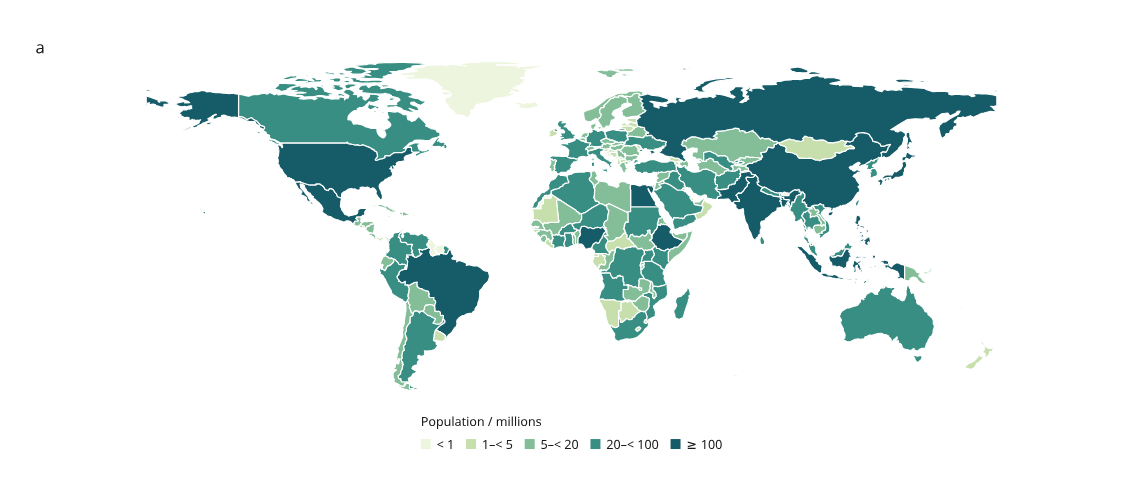
Open the interactive world and Europe maps · Python recipe · Population CSV · GeoJSON
Made with Natural Earth. Its map data are public domain. The data is a pinned historical snapshot: population years vary by row, with 169 of the 176 included rows dated 2019. These are not current population estimates. Every source year is retained in the CSV and interactive table.
Try it
python examples/v4/world_population.py --output out/v4-world
# Open index.html, change the selection or viewport, then Save view.
python examples/v4/world_population.py --state /path/to/view.json --output out/v4-restored
Hungary starts selected in both views. Enter Hungary, France, Europe or
HUN in Search rows. Filtering retains hidden selections and fixed color
bins. Clear the search to show all countries again. Switch between SVG, canvas
and hybrid, pan/zoom the page, or download vector SVG. Integer population
values retain their digits in the table; noninteger numbers use six significant
digits for display. CSV and embedded values retain the source precision.
The example opens offline. It uses the committed inputs and makes no map-service
or data requests. Data attribution appears outside the artwork in the page
footer. The static figure.svg contains both linked maps; world.svg supplies
the single-map overview. The supported GeoJSON subset and map behavior are
described in the region guide.
To replace the table with revised values or a source-year cohort while retaining valid selections, follow Replace figure data. It includes a 169-country example, a change report and exact saved-view reconstruction. The switchable demo embeds both cohorts in one offline page. Choose how to handle missing selected IDs before applying a revision; each cohort keeps its own source credit.
What was imported
The source is Natural Earth's Admin 0 countries at 1:110m, exported at pinned
repository commit 9380cca83db5f9aef52d5e762765100745f84b27 from May 2022.
The manifest records the exact URL,
source SHA-256, prepared-file hashes and every transformation.
- Retain 176 of 177 source features, excluding Antarctica. Some small countries are absent from this coarse source scale. The source's country/map units and boundary depiction are retained.
- Keep polygon parts, holes and coordinates without further simplification.
- Use Natural Earth's
ADM0_A3as the explicit join key. These are source codes, not a claim that every code belongs to ISO 3166. - Copy
ADMIN,CONTINENT,POP_ESTandPOP_YEARinto the table. Map values arePOP_EST / 1,000,000; no population values are simulated or extrapolated. - Remove the old CRS declaration only after verifying it is CRS84, whose longitude/latitude coordinates match the importer. Unused properties are removed from the prepared geometry file.
The world view clips to longitude −180…180 and latitude −60…85; the Europe view clips to −15…45 and 34…72. Both use the existing flat longitude/latitude projection. They share the full table and country geometry, including overseas parts, while their geographic extents differ. This is not a tile-based basemap or an equal-area projection.
To reproduce the inputs from the pinned download:
python tools/prepare_world_map.py --check
# Or verify a local copy, without a network request:
python tools/prepare_world_map.py --source /path/to/ne_110m_admin_0_countries.geojson --check
Without --check, the preparation tool writes the verified derived inputs.
Ordinary example generation never downloads data.
Checks
Regression checks verify input hashes, exact country joins and known interior locations in Hungary, France, the United States, Brazil and Australia. Browser checks cover all three backends at device pixel ratios 1/2, country-name search, linked selection, saved state and source credit. The existing polygon tests continue to check holes, clipping and browser/Python export agreement.
The small synthetic region example and geometry review remain useful regression fixtures. The real dataset is now the main map demonstration.